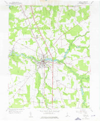
1955 Map of Laurel
USGS Topo · Published 1976About this map
Laurel and the surrounding Sussex County landscape in the mid-1950s are defined by a complex network of wetlands and agricultural tracts. The town serves as a hub, situated where the Pennsylvania railroad crosses Records Pond, an impoundment of Broad Creek. The mapping reveals a rural society structured around crossroad settlements and rural parishes, including Old Christ Ch and St Pauls Ch. Significant water management is evident through extensive drainage infrastructure such as Savannah Ditch and Baker & West Ditch, which allowed for the cultivation of this low-lying Delmarva terrain.
Find a feature on this map
64 named features on this map. Tap any name to fly to it.
Don’t see what you’re looking for? This feature index may not catch every label — zoom into the map to look around manually.
Map Details
Editions of this 1955 Laurel Map
3 editions found
Other maps of this area

1901 · Salisbury
USGS Topo · 1:62,500

1902 · Pittsville
USGS Topo · 1:62,500

1915 · Seaford
USGS Topo · 1:62,500

1917 · Millsboro
USGS Topo · 1:62,500

1938 · Millsboro
USGS Topo · 1:62,500

1942 · Hebron
USGS Topo · 1:24,000

1942 · Delmar
USGS Topo · 1:24,000

1942 · Pittsville
USGS Topo · 1:24,000
1943 · Delmar
USGS Topo · 1:31,680

1943 · Hebron
USGS Topo · 1:31,680