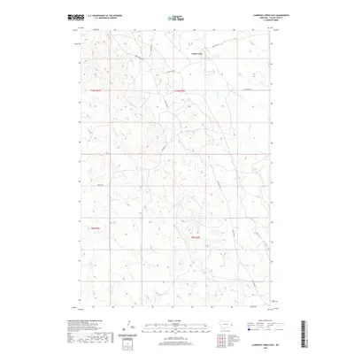
2020 Map of Lawrence Creek East
USGS Topo · Published 2020About this map
Cabin Creek winds through this section of Fallon County, Montana, providing a focal point for a landscape defined by its drainage basins and rural road networks. The water system is well-defined by the Middle Fork Cabin Cr and Dry Fork Cr, which cut through the undulating terrain typical of the eastern Montana high plains. The map illustrates a sparse but deliberate infrastructure geared toward land access, with Anticline Rd and Cabin Creek Rd following the natural contours of the land. This 2020 survey reflects the enduring spatial organization of the American West, where township and range lines like t10n r58e dictate property boundaries and road placements. The presence of named routes like Cap Rock Rd and Plevna Rd N suggests the historical importance of connecting remote ranching outposts to more established regional hubs.
Find a feature on this map
14 named features on this map. Tap any name to fly to it.
Don’t see what you’re looking for? This feature index may not catch every label — zoom into the map to look around manually.
Map Details
Editions of this 2020 Lawrence Creek East Map
This is the sole edition of this map. No revisions or reprints were ever made.
Other maps of this area

1953 · Miles City
USGS Topo · 1:250,000

1957 · Miles City
USGS Topo · 1:250,000

1958 · Miles City
USGS Topo · 1:250,000

1981 · Baker
USGS Topo · 1:100,000

1981 · Baker NE
USGS Topo · 1:24,000

1981 · Lawrence Creek East
USGS Topo · 1:24,000

1981 · Lawrence Creek West
USGS Topo · 1:24,000

1981 · Baker NW
USGS Topo · 1:24,000

1981 · Ayer Spring NE
USGS Topo · 1:24,000
1981 · Plevna
USGS Topo · 1:24,000