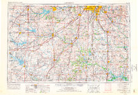
1956 Map of Lawrence
USGS Topo · Published 1976About this map
The Kansas River valley and its surrounding highlands define this mid-1970s landscape, captured during a period of significant reservoir development and suburban expansion. Major water control projects are prominent, including Clinton Lake west of Lawrence and the massive Harry S Truman Reservoir to the southeast. These man-made features altered the drainage of the Marais Des Cygnes River and Neosho River, contrasting with the established agricultural patterns of the eastern Kansas and western Missouri borderlands.
Find a feature on this map
115 named features on this map. Tap any name to fly to it.
Don’t see what you’re looking for? This feature index may not catch every label — zoom into the map to look around manually.
Map Details
Editions of this 1956 Lawrence Map
4 editions found

Other maps of this area

1884 · Fort Scott
USGS Topo · 1:125,000

1885 · Eskridge
USGS Topo · 1:125,000

1885 · Burlington
USGS Topo · 1:125,000

1885 · Eureka
USGS Topo · 1:125,000

1885 · Garnett
USGS Topo · 1:125,000

1885 · Warrensburg
USGS Topo · 1:125,000

1885 · Lawrence
USGS Topo · 1:125,000

1886 · Nevada
USGS Topo · 1:125,000

1886 · Fredonia
USGS Topo · 1:125,000

1886 · Stockton
USGS Topo · 1:125,000