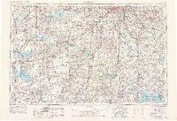
1956 Map of Lawrence
USGS Topo · Published 1976About this map
The confluence of the Kansas River and Wakarusa River defines the landscape surrounding Lawrence, a hub of transit and commerce where the Atchison Topeka and Santa Fe RR and Union Pacific RR intersect. This mid-1970s revision captures the region's hydraulic evolution, showcasing the expansion of Clinton Lake and the John Redmond Reservoir within the Flint Hills National Wildlife Refuge. Cold War-era infrastructure is prominent at Forbes AFB and the Sunflower Ordnance Works, reflecting the era's strategic footprint.
Find a feature on this map
153 named features on this map. Tap any name to fly to it.
Don’t see what you’re looking for? This feature index may not catch every label — zoom into the map to look around manually.
Map Details
Editions of this 1956 Lawrence Map
4 editions found

Other maps of this area

1884 · Fort Scott
USGS Topo · 1:125,000

1885 · Eskridge
USGS Topo · 1:125,000

1885 · Burlington
USGS Topo · 1:125,000

1885 · Eureka
USGS Topo · 1:125,000

1885 · Garnett
USGS Topo · 1:125,000

1885 · Warrensburg
USGS Topo · 1:125,000

1885 · Lawrence
USGS Topo · 1:125,000

1886 · Nevada
USGS Topo · 1:125,000

1886 · Fredonia
USGS Topo · 1:125,000

1886 · Stockton
USGS Topo · 1:125,000