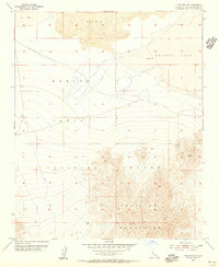
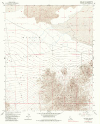
1955 Map of Lead Mountain NE
USGS Topo · Published 1956About this map
The Bullion Mountains dominate this mid-century survey of the California high desert, showing a landscape defined by volcanic activity and military utility. A significant field of Lava spreads across the northern section, bordering the arid basins of Dry Lake and the edge of Bristol Lake. Much of this territory is designated as the Marine Corps Training Center, reflecting the era's focus on expansive training grounds for amphibious and desert warfare. Evidence of earlier human activity is found in isolated industrial markers, such as the America Mine and a lone Shaft located near a winding Jeep Trail. These features, along with scattered Dry Wells, indicate a history of prospecting and resource extraction in a region where water was the primary constraint on development.
Find a feature on this map
10 named features on this map. Tap any name to fly to it.
Don’t see what you’re looking for? This feature index may not catch every label — zoom into the map to look around manually.
Map Details
Editions of this 1955 Lead Mountain NE Map
6 editions found
Other maps of this area

1942 · Amboy
USGS Topo · 1:250,000

1943 · Amboy
USGS Topo · 1:250,000

1954 · Needles
USGS Topo · 1:250,000

1954 · Bristol Lake NW
USGS Topo · 1:24,000

1954 · Amboy Crater
USGS Topo · 1:24,000

1954 · Bagdad SW
USGS Topo · 1:24,000

1954 · Bristol Lake SW
USGS Topo · 1:24,000

1955 · Lead Mountain
USGS Topo · 1:24,000

1955 · Lead Mtn. NE
USGS Topo · 1:24,000

1955 · Lead Mountain SW
USGS Topo · 1:24,000