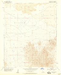
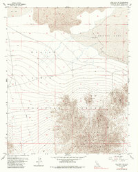
1955 Map of Lead Mountain NE
USGS Topo · Published 1958About this map
The Marine Corps Training Center occupies a significant portion of this Mojave Desert landscape, reflecting the mid-century expansion of military infrastructure in San Bernardino County. In the south, the Bullion Mountains rise sharply, concealing vestiges of desert industry such as the America Mine and a lone Shaft. The geological character of the region is defined by a large expanse of Lava flows to the north, situated between the expansive, arid basins of Dry Lake and Bristol Lake. Transportation is limited to a sparse network of rugged paths, including a named Jeep Trail, highlighting the area's isolation. Evidence of water prospecting in this harsh environment is visible at a Dry Well located on the alluvial fans north of the mountain range.
Find a feature on this map
10 named features on this map. Tap any name to fly to it.
Don’t see what you’re looking for? This feature index may not catch every label — zoom into the map to look around manually.
Map Details
Editions of this 1955 Lead Mountain NE Map
6 editions found
Other maps of this area

1942 · Amboy
USGS Topo · 1:250,000

1943 · Amboy
USGS Topo · 1:250,000

1954 · Needles
USGS Topo · 1:250,000

1954 · Bristol Lake NW
USGS Topo · 1:24,000

1954 · Amboy Crater
USGS Topo · 1:24,000

1954 · Bagdad SW
USGS Topo · 1:24,000

1954 · Bristol Lake SW
USGS Topo · 1:24,000

1955 · Lead Mountain
USGS Topo · 1:24,000

1955 · Lead Mtn. NE
USGS Topo · 1:24,000

1955 · Lead Mountain SW
USGS Topo · 1:24,000