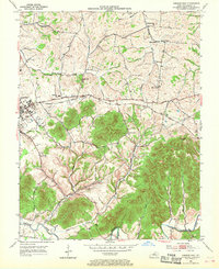
1953 Map of Lebanon East
USGS Topo · Published 1968About this map
The Louisville and Nashville Railroad and the Jane Todd Crawford Trail run parallel through the heart of Marion County, tracing a historic transit corridor toward Lebanon. This 1953 survey captures the landscape just before significant modern development, showing a densely settled rural network of family-named landmarks and community institutions. Numerous churches like Bells Chapel and Bethel Union Ch are scattered among the ridges and valleys defined by Rolling Fork and its tributaries, including Caney Creek and Cartwright Creek. The presence of the Fairgrounds on the eastern edge of Lebanon and the Glasscock Sch suggests the area's mid-century role as a regional hub for education and commerce. To the south and east, the terrain becomes more dramatic near The Narrows and Putnam Knob, where the drainage patterns of Milk Mash Creek and Turkey Pen Hollow indicate a shift toward more wooded, dissected uplands.
Find a feature on this map
34 named features on this map. Tap any name to fly to it.
Don’t see what you’re looking for? This feature index may not catch every label — zoom into the map to look around manually.
Map Details
Editions of this 1953 Lebanon East Map
2 editions found
Other maps of this area

1952 · Bradfordsville
USGS Topo · 1:24,000

1953 · Mackville
USGS Topo · 1:24,000

1953 · Bradfordsville NE
USGS Topo · 1:24,000

1953 · Gravel Switch
USGS Topo · 1:24,000

1953 · Saint Catharine
USGS Topo · 1:24,000

1953 · Lebanon East
USGS Topo · 1:24,000

1953 · Springfield
USGS Topo · 1:24,000

1953 · Spurlington
USGS Topo · 1:24,000

1953 · Lebanon West
USGS Topo · 1:24,000

1953 · Bradfordsville
USGS Topo · 1:24,000