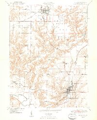
1948 Map of Lewistown
USGS Topo · Published 1948About this map
Lewistown serves as the focal point for this 1948 survey, showing a landscape defined by traditional agriculture, early coal extraction, and the established routes of the Toledo Peoria and Western and the Chicago Burlington and Quincy railroads. The town itself is densely mapped, featuring the County Fairgrounds and several civic landmarks like Oak Hill Cem and St Marys Cem. Moving north toward Cuba, the terrain transitions into industrial zones marked by several Strip Mine operations, providing a clear look at the mid-century mining footprint in Fulton County.
Find a feature on this map
37 named features on this map. Tap any name to fly to it.
Don’t see what you’re looking for? This feature index may not catch every label — zoom into the map to look around manually.
Map Details
Editions of this 1948 Lewistown Map
2 editions found

Other maps of this area

1912 · Canton
USGS Topo · 1:62,500

1915 · Avon
USGS Topo · 1:62,500

1918 · Vermont
USGS Topo · 1:62,500

1921 · Vermont
USGS Topo · 1:62,500

1925 · Havana
USGS Topo · 1:62,500

1944 · Avon
USGS Topo · 1:62,500

1947 · Lewistown
USGS Topo · 1:24,000

1947 · St. David
USGS Topo · 1:24,000

1947 · Havana
USGS Topo · 1:24,000

1948 · Duncan Mills
USGS Topo · 1:24,000