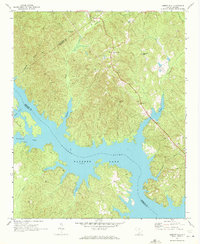
1971 Map of Liberty Hill
USGS Topo · Published 1972About this map
Watere Lake and the Watere River dominate this early 1970s landscape, where the rising waters have created a complex shoreline of inlets and fingers. The settlement of Liberty Hill sits on higher ground overlooking the basin, marked by its Lookout Tower and local institutions such as Oak Spring Ch. The map provides a detailed view of the rural transition as the area developed around the reservoir, capturing numerous creeks that feed the main body of water, including Dutchmans Creek, Singleton Creek, and Rochelle Creek.
Find a feature on this map
23 named features on this map. Tap any name to fly to it.
Don’t see what you’re looking for? This feature index may not catch every label — zoom into the map to look around manually.
Map Details
Editions of this 1971 Liberty Hill Map
This is the sole edition of this map. No revisions or reprints were ever made.
Other maps of this area

1935 · Camden
USGS Topo · 1:48,000

1938 · Camden
USGS Topo · 1:62,500

1941 · Spartanburg
USGS Topo · 1:250,000

1942 · Camden
USGS Topo · 1:125,000

1953 · Spartanburg
USGS Topo · 1:250,000

1960 · Spartanburg
USGS Topo · 1:250,000

1963 · Spartanburg
USGS Topo · 1:250,000

1964 · Spartanburg
USGS Topo · 1:250,000

1968 · Lancaster SE
USGS Topo · 1:24,000

1968 · Heath Springs
USGS Topo · 1:24,000