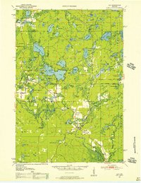
1950 Map of Lily
USGS Topo · Published 1956About this map
The Wolf River winds through the heart of this Northwoods landscape, serving as a focal point for the small settlements and seasonal camps of the mid-century era. In Lily, the confluence of river and rail is evident, with the Minneapolis Sault Ste Marie line supporting local transport and sidings like Pig Snout Siding. The map reveals a community structured around its natural resources and recreational potential, from the established Camp Ma-Ka-Ja-Wan to the numerous scattered lakes such as Rolling Stone Lake, Pickerel Lake, and Crane Lake. Local genealogy and social history are anchored by landmarks like Pearson Cem, the Adventist Sch, and Pearson Sch. Large tracts of the Nicolet National Forest dominate the eastern portion, while expansive wetlands like Dennison Swamp and Woods Island define the varied terrain before the modern development of these lakefront regions.
Find a feature on this map
82 named features on this map. Tap any name to fly to it.
Don’t see what you’re looking for? This feature index may not catch every label — zoom into the map to look around manually.
Map Details
Editions of this 1950 Lily Map
3 editions found

Other maps of this area

1939 · Crandon
USGS Topo · 1:48,000

1939 · Laona
USGS Topo · 1:48,000

1940 · Monico
USGS Topo · 1:48,000

1941 · Crandon
USGS Topo · 1:48,000

1942 · Elcho
USGS Topo · 1:48,000

1942 · Wabeno
USGS Topo · 1:48,000

1942 · Pearson
USGS Topo · 1:48,000

1946 · Laona
USGS Topo · 1:48,000

1947 · Crandon
USGS Topo · 1:48,000

1950 · Wabeno
USGS Topo · 1:48,000