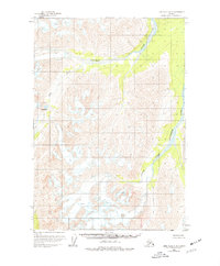
1958 Map of Lime Hills C-2
USGS Topo · Published 1977About this map
The South Fork Kuskokwim River carves a deep glacial path through the mountainous interior of the Lime Hills C-2 quadrangle. This 1950s survey, updated with limited revisions in the mid-1970s, captures a landscape defined by dramatic elevation changes and geological activity. Notable glacial features including various Crevasses are documented among the high peaks, while the Hartman Fork provides a secondary drainage system to the north. These waterways were the primary corridors for movement in a region devoid of established roads or trails during the mid-20th century.
Find a feature on this map
8 named features on this map. Tap any name to fly to it.
Don’t see what you’re looking for? This feature index may not catch every label — zoom into the map to look around manually.
Map Details
Editions of this 1958 Lime Hills C-2 Map
2 editions found
Other maps of this area

1951 · Lime Hills
USGS Topo · 1:250,000

1954 · Lime Hills B-3
USGS Topo · 1:63,360

1958 · Lime Hills C-3
USGS Topo · 1:63,360

1958 · Lime Hills B-1
USGS Topo · 1:63,360
1958 · Lime Hills D-1
USGS Topo · 1:63,360

1958 · Lime Hills C-1
USGS Topo · 1:63,360

1958 · Lime Hills C-2
USGS Topo · 1:63,360

1958 · Lime Hills D-3
USGS Topo · 1:63,360
1958 · Lime Hills B-2
USGS Topo · 1:63,360
1958 · Lime Hills D-2
USGS Topo · 1:63,360