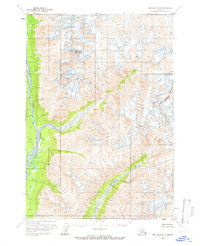
1958 Map of Lime Hills B-2
USGS Topo · Published 1966About this map
Stony River and the Necons River dominate this interior Alaskan landscape, their braided channels cutting through a territory largely defined by high-elevation topography and permanent ice. Mapped from aerial photography taken in the mid-1950s, the sheet captures the transition from the river valleys to the high peaks of the Kenai Peninsula Borough boundary. Snowcap Mountain serves as a central landmark amidst a complex network of unnamed glaciers and crevasses that cover the eastern half of the quadrangle. The lack of roads or established trails highlights the isolation of this wilderness during the late 1950s, where the natural watercourses provided the primary routes for movement. The map preserves the exact positions of these shifting glacial features and river bends before decades of environmental change.
Find a feature on this map
5 named features on this map. Tap any name to fly to it.
Don’t see what you’re looking for? This feature index may not catch every label — zoom into the map to look around manually.
Map Details
Editions of this 1958 Lime Hills B-2 Map
2 editions found
Other maps of this area

1951 · Lime Hills
USGS Topo · 1:250,000

1954 · Lime Hills A-3
USGS Topo · 1:63,360

1954 · Lime Hills B-3
USGS Topo · 1:63,360

1958 · Lime Hills A-2
USGS Topo · 1:63,360

1958 · Lime Hills C-3
USGS Topo · 1:63,360

1958 · Lime Hills B-1
USGS Topo · 1:63,360
1958 · Lime Hills A-1
USGS Topo · 1:63,360

1958 · Lime Hills C-1
USGS Topo · 1:63,360

1958 · Lime Hills C-2
USGS Topo · 1:63,360

1958 · Lime Hills
USGS Topo · 1:250,000