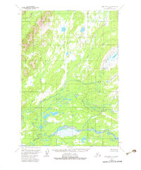
1954 Map of Lime Hills C-5
USGS Topo · Published 1983About this map
The Swift River and its major tributary, the North Fork Swift River, dominate this mid-century landscape in the Lime Hills region. Compiled from aerial photography taken in 1953, the map illustrates a complex network of glacial meltwater and drainage patterns typical of the Alaskan interior. The Gagaryah River cuts through the northwest corner, while the Babel River meanders through the central and northern sections, feeding into a dense mosaic of wetlands and small ponds. This 1954 field-annotated survey provides a clear view of the hydrological system before contemporary environmental shifts, showing no established roads or trails in this part of the territory. The absence of human infrastructure highlights the isolation of the river forks and the surrounding low-relief marshlands, which were interpreted and mapped by the Geological Survey during this intensive period of photogrammetric mapping in Alaska.
Find a feature on this map
4 named features on this map. Tap any name to fly to it.
Don’t see what you’re looking for? This feature index may not catch every label — zoom into the map to look around manually.
Map Details
Editions of this 1954 Lime Hills C-5 Map
2 editions found
Other maps of this area

1951 · Lime Hills
USGS Topo · 1:250,000

1954 · Lime Hills D-6
USGS Topo · 1:63,360

1954 · Lime Hills D-5
USGS Topo · 1:63,360

1954 · Lime Hills C-6
USGS Topo · 1:63,360
1954 · Lime Hills C-5
USGS Topo · 1:63,360

1954 · Lime Hills B-4
USGS Topo · 1:63,360

1954 · Lime Hills B-5
USGS Topo · 1:63,360

1954 · Lime Hills B-6
USGS Topo · 1:63,360

1958 · Lime Hills C-4
USGS Topo · 1:63,360
1958 · Lime Hills D-4
USGS Topo · 1:63,360