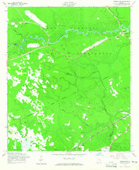
1958 Map of Limerick NW
USGS Topo · Published 1965About this map
The Fort Stewart Military Reservation dominates this coastal Georgia landscape, where the Canoochee River winds through dense forest and wetlands. The geography is defined by a heavy presence of hydraulic infrastructure, including numerous Artesian Wells and Artesian Well sites scattered across the training grounds and surrounding timberlands. Near the southern border, the settlement of Fleming serves as a small rail hub along the Atlantic Coast Line railroad.
Find a feature on this map
20 named features on this map. Tap any name to fly to it.
Don’t see what you’re looking for? This feature index may not catch every label — zoom into the map to look around manually.
Map Details
Editions of this 1958 Limerick NW Map
3 editions found
Other maps of this area

1918 · Hinesville
USGS Topo · 1:62,500

1920 · Pembroke
USGS Topo · 1:62,500

1920 · Meldrim
USGS Topo · 1:62,500

1920 · Limerick
USGS Topo · 1:62,500

1942 · Meldrim
USGS Topo · 1:62,500

1944 · Hinesville
USGS Topo · 1:62,500

1944 · Limerick
USGS Topo · 1:62,500

1946 · Brunswick
USGS Topo · 1:250,000

1947 · Savannah
USGS Topo · 1:250,000

1948 · Brunswick
USGS Topo · 1:250,000