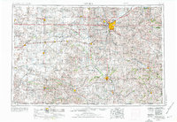
1955 Map of Lincoln
USGS Topo · Published 1976About this map
Lincoln serves as the regional hub for a landscape defined by an extensive rail network and the winding courses of the Big Blue River and Salt Creek. This mid-century survey reveals the city's growth alongside major institutional landmarks like the Lincoln Air Force Station and the U.S. Veterans Hospital. The map illustrates the dominance of the Chicago Burlington and Quincy and Missouri Pacific railroads, which linked smaller agricultural settlements such as McCool Junction, Pleasant Dale, and Waverly to the state capital. Beyond the urban centers, the presence of the Homestead National Monument of America underscores the historical importance of the region's 19th-century settlement. The density of section-line roads and named railroad sidings like Berks Siding provides a clear view of the rural township structure that organized Nebraska's farm economy in the post-war era.
Find a feature on this map
118 named features on this map. Tap any name to fly to it.
Don’t see what you’re looking for? This feature index may not catch every label — zoom into the map to look around manually.
Map Details
Editions of this 1955 Lincoln Map
5 editions found

Other maps of this area

1888 · Hiawatha
USGS Topo · 1:125,000

1889 · Seneca
USGS Topo · 1:125,000

1889 · Marysville
USGS Topo · 1:125,000

1892 · Concordia
USGS Topo · 1:125,000

1893 · Washington
USGS Topo · 1:125,000

1893 · Fremont
USGS Topo · 1:125,000

1894 · Seneca
USGS Topo · 1:125,000

1894 · Mankato
USGS Topo · 1:125,000

1894 · Hiawatha
USGS Topo · 1:125,000

1894 · Marysville
USGS Topo · 1:125,000