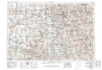
1955 Map of Lincoln
USGS Topo · Published 1986About this map
The city of Lincoln serves as the focal point of this regional study, which extends across the agricultural plains of eastern Nebraska to the Kansas border. The landscape is defined by the grid-like precision of section lines and a robust transportation network, featuring the Burlington Northern and Union Pacific railroads alongside established routes like U. S. 81. Water management is a significant theme of the era, illustrated by the series of reservoirs surrounding the capital, including Branched Oak Lake State Recreation Area and Pawnee Lake State Recreation Area. To the south, the Homestead Nat Mon of America near Beatrice commemorates the pioneering history of the region. From smaller junctions like McCool Junction to established towns like Seward and York, the map traces the mid-century evolution of these rural communities and their connection to the wider Great Plains economy.
Find a feature on this map
120 named features on this map. Tap any name to fly to it.
Don’t see what you’re looking for? This feature index may not catch every label — zoom into the map to look around manually.
Map Details
Editions of this 1955 Lincoln Map
5 editions found

Other maps of this area

1888 · Hiawatha
USGS Topo · 1:125,000

1889 · Seneca
USGS Topo · 1:125,000

1889 · Marysville
USGS Topo · 1:125,000

1892 · Concordia
USGS Topo · 1:125,000

1893 · Washington
USGS Topo · 1:125,000

1893 · Fremont
USGS Topo · 1:125,000

1894 · Seneca
USGS Topo · 1:125,000

1894 · Mankato
USGS Topo · 1:125,000

1894 · Hiawatha
USGS Topo · 1:125,000

1894 · Marysville
USGS Topo · 1:125,000