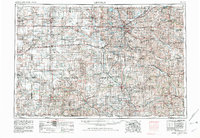
1955 Map of Lincoln
USGS Topo · Published 1982About this map
The Lincoln metropolitan area and the fertile plains of southeast Nebraska are captured here at a moment of significant infrastructure expansion. The landscape is defined by the radial drainage of the Big Blue River and Little Blue River systems, which historically dictated the paths of the Union Pacific and Burlington Northern railroads. A notable concentration of water management is visible in the network of reservoirs surrounding the capital, including Branched Oak Lake and Pawnee Lake, reflecting mid-century flood control and recreation efforts. To the south, the Homestead National Monument of America marks the historic site of the first claim under the Homestead Act, anchoring the region's pioneer heritage. In the northern reaches, the rolling terrain of the Bohemian Alps provides a distinct geographical contrast to the grid-patterned agricultural lands that dominate the counties of York, Fillmore, and Thayer.
Find a feature on this map
193 named features on this map. Tap any name to fly to it.
Don’t see what you’re looking for? This feature index may not catch every label — zoom into the map to look around manually.
Map Details
Editions of this 1955 Lincoln Map
5 editions found

Other maps of this area

1888 · Hiawatha
USGS Topo · 1:125,000

1889 · Seneca
USGS Topo · 1:125,000

1889 · Marysville
USGS Topo · 1:125,000

1892 · Concordia
USGS Topo · 1:125,000

1893 · Washington
USGS Topo · 1:125,000

1893 · Fremont
USGS Topo · 1:125,000

1894 · Seneca
USGS Topo · 1:125,000

1894 · Mankato
USGS Topo · 1:125,000

1894 · Hiawatha
USGS Topo · 1:125,000

1894 · Marysville
USGS Topo · 1:125,000