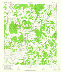
1961 Map of Lincoln
USGS Topo · Published 1962About this map
The confluence of Middle Yegua Creek and West Yegua Creek defines this rural landscape in Lee County, where agricultural field lines are intricately mapped alongside numerous gravel extractions. The settlement of Lincoln serves as a central hub, situated near an Old Railroad Grade that speaks to the changing transportation priorities of the early 1960s. Further southeast, the Southern Pacific line remains active, passing near Loebau and the former Loebau Siding (Site). The map is particularly rich for genealogists, detailing several family and community landmarks such as St Peters Cem, Evergreen Cem, and New Bethel Cem. Education and faith are anchored at sites like Doak Spring Sch and the Smith Chapel, while the distinctive Buzzard Knobs provide a prominent topographic reference point amidst the network of creeks and hollows.
Find a feature on this map
40 named features on this map. Tap any name to fly to it.
Don’t see what you’re looking for? This feature index may not catch every label — zoom into the map to look around manually.
Map Details
Editions of this 1961 Lincoln Map
Other maps of this area

1885 · Bastrop
USGS Topo · 1:125,000

1893 · Bastrop
USGS Topo · 1:125,000

1904 · Bastrop
USGS Topo · 1:125,000

1919 · Giddings
USGS Topo · 1:62,500

1919 · Dime Box
USGS Topo · 1:62,500

1948 · Smithville
USGS Topo · 1:62,500

1948 · Lexington
USGS Topo · 1:62,500

1950 · Lexington
USGS Topo · 1:62,500

1950 · Smithville
USGS Topo · 1:62,500

1954 · Austin
USGS Topo · 1:250,000