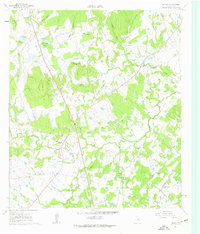
1961 Map of Lincoln
USGS Topo · Published 1962About this map
Middle Yegua Creek and West Yegua Creek converge in this central Texas landscape, defining a network of drainage branches and hollows. The settlement of Lincoln serves as a local hub near the Old Railroad Grade, while the Southern Pacific railroad cuts through the southeast corner at Loebau Siding (Site). The era's rural life is visible through scattered community landmarks like Doat Spring Sch, St Johns Sch, and numerous country churches such as New Bethel Ch and Smith Chapel. Significant gravel extraction is evident from the concentration of Gravel Pits north of Lincoln. Local family names are preserved in features like Molly Smith Lake and Gloyds Cem, while the distinct elevation of Buzzard Knobs rises above the surrounding creek valleys.
Find a feature on this map
45 named features on this map. Tap any name to fly to it.
Don’t see what you’re looking for? This feature index may not catch every label — zoom into the map to look around manually.
Map Details
Editions of this 1961 Lincoln Map
Other maps of this area

1885 · Bastrop
USGS Topo · 1:125,000

1893 · Bastrop
USGS Topo · 1:125,000

1904 · Bastrop
USGS Topo · 1:125,000

1919 · Giddings
USGS Topo · 1:62,500

1919 · Dime Box
USGS Topo · 1:62,500

1948 · Smithville
USGS Topo · 1:62,500

1948 · Lexington
USGS Topo · 1:62,500

1950 · Lexington
USGS Topo · 1:62,500

1950 · Smithville
USGS Topo · 1:62,500

1954 · Austin
USGS Topo · 1:250,000