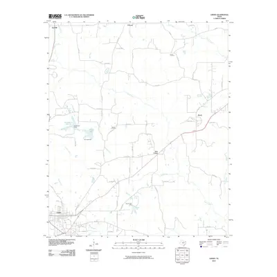
2010 Map of Linden
USGS Topo · Published 2010About this map
Linden serves as the focal point for this section of Cass County, where a network of county roads branches out into the surrounding piney woods and agricultural lands. Small settlements such as O'Farrell and Roach anchor the rural landscape, while family and community heritage is preserved at Echols Cemetery and Barnes Cemetery. The terrain is defined by a dense system of waterways, including Frazier Creek and Henderson Creek, which feed into local catchments. Notable water management features include the Silt Retainer Reservoir and its associated levee, as well as Price Lake and Harvey Lake. These reservoirs reflect the region's managed landscape, providing essential water resources and drainage control for the various farm-to-market routes that crisscross the quadrangle. The map details a transition from the structured street grid of the county seat to the outlying hamlets of New Colony and Red Hill.
Find a feature on this map
63 named features on this map. Tap any name to fly to it.
Don’t see what you’re looking for? This feature index may not catch every label — zoom into the map to look around manually.
Map Details
Editions of this 2010 Linden Map
This is the sole edition of this map. No revisions or reprints were ever made.
Other maps of this area

1907 · Atlanta
USGS Topo · 1:62,500

1910 · Linden
USGS Topo · 1:62,500

1910 · Atlanta
USGS Topo · 1:62,500

1944 · Kildare
USGS Topo · 1:62,500

1948 · Kildare
USGS Topo · 1:62,500

1953 · Texarkana
USGS Topo · 1:250,000

1956 · Texarkana
USGS Topo · 1:250,000

1956 · Tyler
USGS Topo · 1:250,000

1961 · Cunningham Creek
USGS Topo · 1:24,000

1962 · Lanier
USGS Topo · 1:24,000