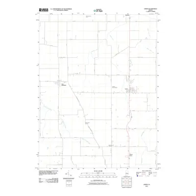
2010 Map of Linden
USGS Topo · Published 2010About this map
Linden and New Richmond anchor this agricultural landscape in northwestern Indiana, where a grid of rural routes like New Richmond Rd and S County Line Rd connects small settlements and family farms. The terrain is defined by a complex network of waterways, including the North Fork Coal Creek and Black Creek, as well as numerous engineered drainage systems such as Lofland Ditch and Stoddard Ditch. For local historians and genealogists, the map identifies specific burial sites like the Wilson Killen Cemetery and Mount Pleasant Cemetery, providing precise locations for family research. Transportation and local utility are reflected in features like the Wilkins Strip Airport and the Grimes Farm Strip, while the community of Cherry Grove sits along the southern transit corridor, illustrating the late 20th-century development of these historic Montgomery County townships.
Find a feature on this map
51 named features on this map. Tap any name to fly to it.
Don’t see what you’re looking for? This feature index may not catch every label — zoom into the map to look around manually.
Map Details
Editions of this 2010 Linden Map
This is the sole edition of this map. No revisions or reprints were ever made.
Other maps of this area

1953 · Danville
USGS Topo · 1:250,000

1955 · Danville
USGS Topo · 1:250,000

1956 · Danville
USGS Topo · 1:250,000

1956 · Crawfordsville
USGS Topo · 1:24,000

1958 · Darlington
USGS Topo · 1:24,000

1958 · Linden
USGS Topo · 1:24,000

1958 · Kirkpatrick
USGS Topo · 1:24,000

1961 · Romney
USGS Topo · 1:24,000

1961 · Stockwell
USGS Topo · 1:24,000
1962 · Waynetown
USGS Topo · 1:24,000