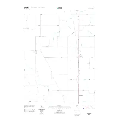
2013 Map of Linden
USGS Topo · Published 2013About this map
Linden and New Richmond anchor this corner of Montgomery County, where the landscape is defined by a dense network of agricultural drainage infrastructure and small rural crossroads. The area around Cherry Grove and Romney reveals a transition from the structured grid of county roads to the meandering paths of the N Fork Coal Cr and Black Cr. This 2013 survey illustrates the modern continuation of a long-standing Midwestern farming economy, where local waterways like Lofland Ditch and Stoddard Ditch have been engineered into the landscape to support high-productivity agriculture. The map is particularly useful for identifying contemporary property boundaries and the precise routes of rural corridors such as N New Richmond Rd and Bennett Rd in relation to the established town centers.
Find a feature on this map
59 named features on this map. Tap any name to fly to it.
Don’t see what you’re looking for? This feature index may not catch every label — zoom into the map to look around manually.
Map Details
Editions of this 2013 Linden Map
This is the sole edition of this map. No revisions or reprints were ever made.
Other maps of this area

1953 · Danville
USGS Topo · 1:250,000

1955 · Danville
USGS Topo · 1:250,000

1956 · Danville
USGS Topo · 1:250,000

1956 · Crawfordsville
USGS Topo · 1:24,000

1958 · Darlington
USGS Topo · 1:24,000

1958 · Linden
USGS Topo · 1:24,000

1958 · Kirkpatrick
USGS Topo · 1:24,000

1961 · Romney
USGS Topo · 1:24,000

1961 · Stockwell
USGS Topo · 1:24,000
1962 · Waynetown
USGS Topo · 1:24,000