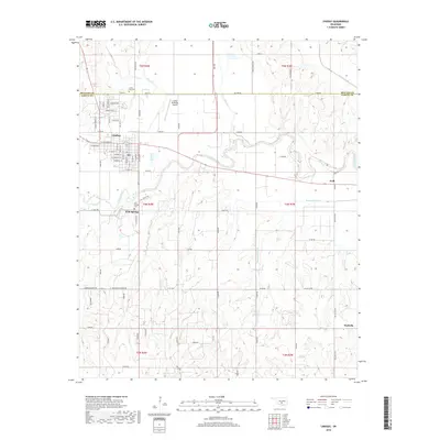
2018 Map of Lindsay
USGS Topo · Published 2018About this map
The Washita River meanders across this landscape, separating the developed streets of Lindsay from the smaller community of Erin Springs. This portion of Garvin County is characterized by a mix of municipal infrastructure and rural drainage networks, where Bear Cr and Hybarger Cr feed into the primary river valley. For those researching local history or genealogy, the map identifies Green Hill Cem north of town and the Erin Springs Cem near the riverbanks. The settlement of Wallville is positioned in the southeast corner, connected to the broader area by a network of county roads like Wallville Rd. From the runways of the Lindsay Municipal Airport to the rural crossings of Happy Hollow Cr, this 2018 survey documents the modern topography of a region defined by its agricultural valley and established road grid.
Find a feature on this map
51 named features on this map. Tap any name to fly to it.
Don’t see what you’re looking for? This feature index may not catch every label — zoom into the map to look around manually.
Map Details
Editions of this 2018 Lindsay Map
This is the sole edition of this map. No revisions or reprints were ever made.
Other maps of this area

1898 · Pauls Valley
USGS Topo · 1:125,000

1902 · Pauls Valley
USGS Topo · 1:125,000

1902 · Rush Springs
USGS Topo · 1:125,000

1957 · Ardmore
USGS Topo · 1:250,000

1963 · Ardmore
USGS Topo · 1:250,000

1965 · Maysville
USGS Topo · 1:24,000
1965 · Stealy
USGS Topo · 1:24,000

1966 · Lindsay
USGS Topo · 1:24,000
1966 · Criner
USGS Topo · 1:24,000

1966 · Lindsay SW
USGS Topo · 1:24,000