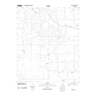
2009 Map of Lindsay SW
USGS Topo · Published 2009About this map
The Washita River meanders across this rural Oklahoma landscape, defining a wide floodplain fed by numerous small tributaries and a complex system of watershed dams. In the early 21st century, this area south of Lindsay is characterized by its agricultural grid, where roads like Co Rd 1480 and County Line Rd delineate large tracts of land. The topographic data reveals a highly managed drainage system, featuring a series of numbered flood-control structures such as the Round Creek Site 1 Dam and the Bear Hybarger Site 4 Dam. These engineered features, scattered along Hybarger Creek, Larimore Creek, and Sandy Creek, highlight the regional efforts to manage runoff and erosion within the Washita watershed. The map provides a detailed view of the local infrastructure, including specific sections of the Garvin County road network such as Garvin Co Paint Rd.
Find a feature on this map
42 named features on this map. Tap any name to fly to it.
Don’t see what you’re looking for? This feature index may not catch every label — zoom into the map to look around manually.
Map Details
Editions of this 2009 Lindsay SW Map
This is the sole edition of this map. No revisions or reprints were ever made.
Other maps of this area

1902 · Rush Springs
USGS Topo · 1:125,000

1949 · Rush Springs
USGS Topo · 1:62,500

1950 · Rush Springs
USGS Topo · 1:62,500

1950 · Marlow
USGS Topo · 1:62,500

1951 · Marlow
USGS Topo · 1:62,500

1957 · Ardmore
USGS Topo · 1:250,000

1963 · Ardmore
USGS Topo · 1:250,000

1966 · Lindsay
USGS Topo · 1:24,000
1966 · Criner
USGS Topo · 1:24,000

1966 · Lindsay SW
USGS Topo · 1:24,000