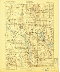
1908 Map of Linesville
USGS Topo · Published 1917About this map
The Shenango River and its associated wetlands dominate this portion of Crawford County, showing the landscape before later water management projects significantly altered the drainage of the Conneaut Marsh. At the time of this 1906 survey, the Bessemer and Lake Erie railroad served as a vital corridor through the valley, connecting settlements like Shermansville and Hartstown. The map captures a high density of rural institutions, with dozens of family-named schoolhouses such as Gamble School and McIntyre School serving the agrarian communities of Summit and Sadsbury townships.
Find a feature on this map
84 named features on this map. Tap any name to fly to it.
Don’t see what you’re looking for? This feature index may not catch every label — zoom into the map to look around manually.
Map Details
Editions of this 1908 Linesville Map
4 editions found
Other maps of this area

1900 · Girard
USGS Topo · 1:62,500

1905 · Andover
USGS Topo · 1:48,000

1906 · Conneaut
USGS Topo · 1:62,500

1906 · Linesville
USGS Topo · 1:62,500

1907 · Andover
USGS Topo · 1:62,500

1907 · Kinsman
USGS Topo · 1:62,500

1908 · Shenango
USGS Topo · 1:62,500

1908 · Linesville
USGS Topo · 1:62,500

1911 · Stoneboro
USGS Topo · 1:62,500

1913 · Stoneboro
USGS Topo · 1:62,500
Featured Places
- Linesville, PA
- Conneaut Lake, PA
- Summerhill Township, PA
- Pymatuning Central, PA
- West Fallowfield Township, PA