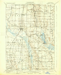
1908 Map of Linesville
USGS Topo · Published 1931About this map
Pymatuning Swamp dominates the western portion of this Crawford County landscape, appearing here as an expansive wetland before its mid-century transformation. The eastern half of the map is anchored by Conneaut Lake, showing the early 20th-century development of Exposition Park and a mapped Steamboat Route crossing the water. This era highlights a dense network of local rail infrastructure, including the Bessemer and Lake Erie Road and the Erie and Pittsburg Division, which supported the growth of numerous rural stations and post offices.
Find a feature on this map
93 named features on this map. Tap any name to fly to it.
Don’t see what you’re looking for? This feature index may not catch every label — zoom into the map to look around manually.
Map Details
Editions of this 1908 Linesville Map
4 editions found
Other maps of this area

1900 · Girard
USGS Topo · 1:62,500

1905 · Andover
USGS Topo · 1:48,000

1906 · Conneaut
USGS Topo · 1:62,500

1906 · Linesville
USGS Topo · 1:62,500

1907 · Andover
USGS Topo · 1:62,500

1907 · Kinsman
USGS Topo · 1:62,500

1908 · Shenango
USGS Topo · 1:62,500

1908 · Linesville
USGS Topo · 1:62,500

1911 · Stoneboro
USGS Topo · 1:62,500

1913 · Stoneboro
USGS Topo · 1:62,500
Featured Places
- Linesville, PA
- Conneaut Lake, PA
- Summerhill Township, PA
- Pymatuning Central, PA
- West Fallowfield Township, PA