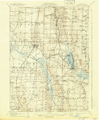
1908 Map of Linesville
USGS Topo · Published 1943About this map
Pymatuning Swamp dominates the western half of this 1906 survey, showing the landscape before the massive reservoir project forever changed the Shenango River basin. The area is a complex network of small agricultural settlements and rural schoolhouses, including the Raceground School and De Arment School, connected by an expanding rail system. The Pennsylvania System and Bessemer and Lake Erie RR cut through the terrain, serving towns like Linesville and Hartstown. Near the eastern edge, Conneaut Lake is already established as a destination, with Exposition Park on its western shore. This era captures the height of the rural school system, with nearly every township section containing a named schoolhouse like Inlet School or Smith School, providing a detailed look at Crawford County's early twentieth-century social geography.
Find a feature on this map
86 named features on this map. Tap any name to fly to it.
Don’t see what you’re looking for? This feature index may not catch every label — zoom into the map to look around manually.
Map Details
Editions of this 1908 Linesville Map
4 editions found
Other maps of this area

1900 · Girard
USGS Topo · 1:62,500

1905 · Andover
USGS Topo · 1:48,000

1906 · Conneaut
USGS Topo · 1:62,500

1906 · Linesville
USGS Topo · 1:62,500

1907 · Andover
USGS Topo · 1:62,500

1907 · Kinsman
USGS Topo · 1:62,500

1908 · Shenango
USGS Topo · 1:62,500

1908 · Linesville
USGS Topo · 1:62,500

1911 · Stoneboro
USGS Topo · 1:62,500

1913 · Stoneboro
USGS Topo · 1:62,500
Featured Places
- Linesville, PA
- Conneaut Lake, PA
- Summerhill Township, PA
- Pymatuning Central, PA
- West Fallowfield Township, PA