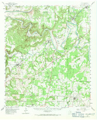
1959 Map of Lipan
USGS Topo · Published 1971About this map
Brazos River meanders sharply through the northern landscape, carving deep, named loops such as John Hittson Bend, Chestnut Bend, and Polk Stalk Bend. These serpentine water features define the topography between Village Bend and the settlement of Bennett. The mapping reflects a rural Texas transition, where early community hubs like Santo and Lipan anchor a network of country roads, including the American Legion Memorial Highway.
Find a feature on this map
67 named features on this map. Tap any name to fly to it.
Don’t see what you’re looking for? This feature index may not catch every label — zoom into the map to look around manually.
Map Details
Editions of this 1959 Lipan Map
Other maps of this area

1889 · Granbury
USGS Topo · 1:125,000

1890 · Stephenville
USGS Topo · 1:125,000

1891 · Weatherford
USGS Topo · 1:125,000

1891 · Palo Pinto
USGS Topo · 1:125,000

1893 · Weatherford
USGS Topo · 1:125,000

1918 · Palo Pinto
USGS Topo · 1:125,000

1920 · Stephenville
USGS Topo · 1:125,000

1925 · Palo Pinto 4-b
USGS Topo · 1:48,000

1927 · Pickwick
USGS Topo · 1:62,500

1927 · Mineral Wells
USGS Topo · 1:62,500