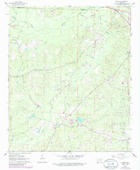
1962 Map of Lisbon
USGS Topo · Published 1986About this map
Lisbon Oil and Gas Field and several neighboring extraction zones dominate this South Arkansas landscape, reflecting the heavy industrial footprint of petroleum production in the early 1960s. The settlement of Lisbon sits as a central hub amidst a network of rural churches and family burial grounds, including Sweet Canaan Ch and the Lone Oak Cem. The terrain is defined by the winding paths of Smackover Creek and Richland Creek, which cut through the wooded hills and dales of the Ouachita and Union county line. Local genealogists will find value in the specific placement of community landmarks like Dumas City and several smaller cemeteries such as Yocum Cem and Hicks Cem, which are documented alongside the infrastructure of the Pace City Oil and Gas Field and Bear Creek Oil and Gas Field.
Find a feature on this map
23 named features on this map. Tap any name to fly to it.
Don’t see what you’re looking for? This feature index may not catch every label — zoom into the map to look around manually.
Map Details
Editions of this 1962 Lisbon Map
3 editions found
Other maps of this area

1927 · El Dorado
USGS Topo · 1:62,500

1930 · El Dorado
USGS Topo · 1:62,500

1951 · El Dorado
USGS Topo · 1:62,500

1953 · El Dorado
USGS Topo · 1:250,000

1957 · El Dorado
USGS Topo · 1:250,000

1958 · El Dorado
USGS Topo · 1:250,000

1960 · El Dorado
USGS Topo · 1:250,000

1962 · Lisbon
USGS Topo · 1:24,000

1962 · Louann
USGS Topo · 1:24,000

1962 · Buena Vista
USGS Topo · 1:24,000