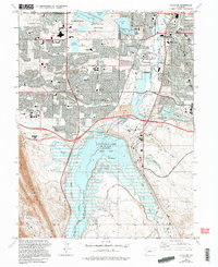
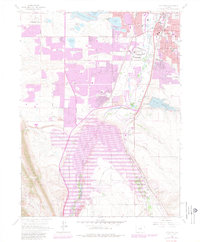
1965 Map of Littleton
USGS Topo · Published 1994About this map
Chatfield Lake dominates the southern landscape of this mid-century survey, its expansive waters and the adjacent Chatfield State Park providing a clear recreational and flood-control anchor for the growing suburbs south of Denver. The terrain is defined by the confluence of the South Platte River and Plum Creek, which navigate a complex network of reservoirs including Me Lellan Reservoir and Bowles Reservoir No 1. This era shows a community in transition, where new residential infrastructure like the Southwest Plaza Mall and schools such as Columbine High Sch and St Marys Sch sit alongside industrial elements like the Coal Mine road and the dual tracks of the Denver & Rio Grande Western RR and Atchison Topeka and Santa Fe RR. Further south, smaller locales like Blakeland and Arequia mark the points where established rail lines meet the emerging suburban fringe.
Find a feature on this map
83 named features on this map. Tap any name to fly to it.
Don’t see what you’re looking for? This feature index may not catch every label — zoom into the map to look around manually.
Map Details
Editions of this 1965 Littleton Map
5 editions found
Other maps of this area

1890 · East Denver
USGS Topo · 1:125,000

1893 · Platte Canyon
USGS Topo · 1:125,000

1894 · Castle Rock
USGS Topo · 1:125,000

1899 · West Denver
USGS Topo · 1:125,000

1913 · Castle Rock
USGS Topo · 1:125,000

1935 · East Denver Nos. 3 and 4
USGS Topo · 1:48,000

1938 · Morrison
USGS Topo · 1:24,000

1940 · Englewood
USGS Topo · 1:31,680

1940 · Castle Rock
USGS Topo · 1:62,500

1941 · Fort Logan
USGS Topo · 1:31,680