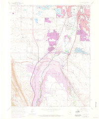
1965 Map of Littleton
USGS Topo · Published 1973About this map
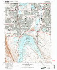
The South Platte River corridor south of Denver undergoes a significant transformation on this sheet, dominated by the emergence of Chatfield Lake. As the Chatfield State Recreation Area takes shape, it impacts earlier local features like the small settlement of Arequia and the surrounding farmland. The map records the suburban expansion around Littleton, where new residential developments like Columbine Valley and Columbine Hills Sch appear alongside established landmarks such as the Littleton Cem and St Marys Sch.
Find a feature on this map
54 named features on this map. Tap any name to fly to it.
Don’t see what you’re looking for? This feature index may not catch every label — zoom into the map to look around manually.
Map Details
Editions of this 1965 Littleton Map
5 editions found
Other maps of this area

1890 · East Denver
USGS Topo · 1:125,000

1893 · Platte Canyon
USGS Topo · 1:125,000

1894 · Castle Rock
USGS Topo · 1:125,000

1899 · West Denver
USGS Topo · 1:125,000

1913 · Castle Rock
USGS Topo · 1:125,000

1935 · East Denver Nos. 3 and 4
USGS Topo · 1:48,000

1938 · Morrison
USGS Topo · 1:24,000

1940 · Englewood
USGS Topo · 1:31,680

1940 · Castle Rock
USGS Topo · 1:62,500

1941 · Fort Logan
USGS Topo · 1:31,680