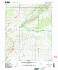
1951 Map of Livengood B-2
USGS Topo · Published 1991About this map
White Mountains dominate this 1951 topographic landscape, characterized by the winding course of Beaver Creek and the Tatalina River. The area is part of the White Mountains National Recreation Area, where early infrastructure is represented by remote outposts like the Borealis-Le Fevre Cabin and scattered cabin sites. Transportation in this interior region relied heavily on specialized routes and aviation, as seen by the White Mountain Trail (Winter) and local airstrips including Hermans Landing Strip and Shebal Landing Strip. The presence of the Pack Trail and Mountain Trail suggests a network of ground travel used before or alongside the establishment of the Fairbanks Meridian boundary lines. Hydrological features such as Wickersham Creek, Montana Creek, and Moose Creek define the drainage patterns of the limestone-rich valleys found within these northern uplands.
Find a feature on this map
22 named features on this map. Tap any name to fly to it.
Don’t see what you’re looking for? This feature index may not catch every label — zoom into the map to look around manually.
Map Details
Editions of this 1951 Livengood B-2 Map
3 editions found
Other maps of this area

1945 · Livengood
USGS Topo · 1:250,000

1951 · Livengood
USGS Topo · 1:250,000

1951 · Livengood C-2
USGS Topo · 1:63,360

1951 · Livengood C-1
USGS Topo · 1:63,360

1951 · Livengood B-2
USGS Topo · 1:63,360

1952 · Livengood A-2
USGS Topo · 1:63,360

1952 · Livengood A-1
USGS Topo · 1:63,360

1953 · Livengood A-3
USGS Topo · 1:63,360

1954 · Livengood C-2
USGS Topo · 1:63,360

1954 · Livengood C-1
USGS Topo · 1:63,360