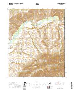
2017 Map of Livengood C-1 NW
USGS Topo · Published 2017About this map
Beaver Creek winds through the northern reaches of this landscape, carving a prominent valley amidst the rugged contours of the interior. To the south, the terrain rises toward the White Mountains, where the elevation increases significantly from the river basin below. This 2017 survey reveals a largely untouched wilderness area within the Yukon-Koyukuk region, where drainage patterns like Lost Horizon Cr define the movement of water through the high-altitude topography. The absence of roads or permanent structures reflects the remote nature of this portion of the Alaskan interior, making it a critical reference for understanding the natural geography of the region before any modern development or transit corridors were established.
Find a feature on this map
9 named features on this map. Tap any name to fly to it.
Don’t see what you’re looking for? This feature index may not catch every label — zoom into the map to look around manually.
Map Details
Editions of this 2017 Livengood C-1 NW Map
This is the sole edition of this map. No revisions or reprints were ever made.
Other maps of this area

1945 · Livengood
USGS Topo · 1:250,000

1951 · Livengood
USGS Topo · 1:250,000

1951 · Livengood C-2
USGS Topo · 1:63,360

1951 · Livengood C-1
USGS Topo · 1:63,360

1952 · Livengood D-2
USGS Topo · 1:63,360

1952 · Livengood D-1
USGS Topo · 1:63,360

1954 · Livengood C-2
USGS Topo · 1:63,360

1954 · Livengood C-1
USGS Topo · 1:63,360
1954 · Livengood D-2
USGS Topo · 1:63,360
1954 · Livengood D-1
USGS Topo · 1:63,360