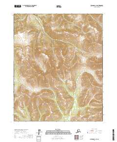
2017 Map of Livengood C-1 SE
USGS Topo · Published 2017About this map
Willow Cr and O'Brien Cr define the hydrological character of this interior Alaskan landscape, which is marked by high-elevation drainage patterns and steep relief. The topography is dominated by the ridges and valleys typical of the Yukon-Koyukuk region, where small seasonal waterways like Fossil Cr have carved distinct paths through the wilderness. This survey demonstrates the township and range grid system as it overlays the unpopulated territory of the northern interior, primarily focused on the natural elevations and the headwaters of these critical tributaries. The absence of roads or permanent structures reflects the primary use of this land for resource navigation or seasonal passage rather than fixed settlement.
Find a feature on this map
9 named features on this map. Tap any name to fly to it.
Don’t see what you’re looking for? This feature index may not catch every label — zoom into the map to look around manually.
Map Details
Editions of this 2017 Livengood C-1 SE Map
This is the sole edition of this map. No revisions or reprints were ever made.
Other maps of this area

1945 · Livengood
USGS Topo · 1:250,000

1951 · Livengood
USGS Topo · 1:250,000

1951 · Circle
USGS Topo · 1:250,000

1951 · Livengood C-1
USGS Topo · 1:63,360

1951 · Circle C-6
USGS Topo · 1:63,360

1954 · Circle B-6
USGS Topo · 1:63,360

1954 · Livengood C-1
USGS Topo · 1:63,360
1954 · Circle C-6
USGS Topo · 1:63,360

1954 · Livengood B-1
USGS Topo · 1:63,360

1955 · Circle
USGS Topo · 1:250,000