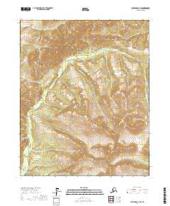
2017 Map of Livengood C-1 SW
USGS Topo · Published 2017About this map
Cache Mtn rises above a wilderness landscape defined by deep drainage systems and high ridges in the Yukon-Koyukuk Census Area. This 2017 survey details the complex hydrography of the region, where the headwaters of Fossil Cr and Big Brook Cr carve through the interior highlands. The terrain is marked by significant geographic landmarks including Windy Gap, which provides a natural passage between the ridgelines, and Brachipod Gulch to the north. These features reflect the geological character of the Alaska interior, where names like Limestone Gulch suggest the mineral composition of the surrounding slopes. The absence of roads or established settlements emphasizes the remote nature of this part of the Livengood quadrangle, preserving the topography as it appeared in the early 21st century.
Find a feature on this map
10 named features on this map. Tap any name to fly to it.
Don’t see what you’re looking for? This feature index may not catch every label — zoom into the map to look around manually.
Map Details
Editions of this 2017 Livengood C-1 SW Map
This is the sole edition of this map. No revisions or reprints were ever made.
Other maps of this area

1945 · Livengood
USGS Topo · 1:250,000

1951 · Livengood
USGS Topo · 1:250,000

1951 · Livengood C-2
USGS Topo · 1:63,360

1951 · Livengood C-1
USGS Topo · 1:63,360

1951 · Livengood B-2
USGS Topo · 1:63,360

1954 · Livengood C-2
USGS Topo · 1:63,360

1954 · Livengood C-1
USGS Topo · 1:63,360
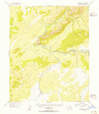
1954 · Livengood B-2
USGS Topo · 1:63,360

1954 · Livengood B-1
USGS Topo · 1:63,360

1956 · Livengood
USGS Topo · 1:250,000