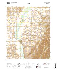
2017 Map of Livengood C-2 SE
USGS Topo · Published 2017About this map
Beaver Creek meanders through the central valley of this northern interior landscape, defining the drainage patterns between the foothills of the White Mountains. This 2017 survey by the U.S. Geological Survey illustrates the transition from high-elevation terrain to the riparian corridors of the Yukon-Koyukuk region. In the eastern portion of the map, the elevation rises sharply toward Limestone Gulch, where several smaller tributaries including Lost Horizon Cr originate before descending toward the main valley floor. The map highlights a largely roadless area where the topography is defined by the sharp contours of the White Mountains and the winding path of Colorado Cr. The land is organized by the Public Land Survey System grids of t9n r1e and t8n r1w, reflecting the formal administrative mapping of this remote Alaskan wilderness.
Find a feature on this map
9 named features on this map. Tap any name to fly to it.
Don’t see what you’re looking for? This feature index may not catch every label — zoom into the map to look around manually.
Map Details
Editions of this 2017 Livengood C-2 SE Map
This is the sole edition of this map. No revisions or reprints were ever made.
Other maps of this area

1945 · Livengood
USGS Topo · 1:250,000

1951 · Livengood
USGS Topo · 1:250,000

1951 · Livengood C-2
USGS Topo · 1:63,360

1951 · Livengood C-1
USGS Topo · 1:63,360

1951 · Livengood B-2
USGS Topo · 1:63,360

1954 · Livengood C-2
USGS Topo · 1:63,360

1954 · Livengood C-1
USGS Topo · 1:63,360
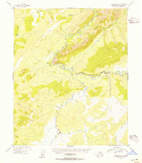
1954 · Livengood B-2
USGS Topo · 1:63,360

1954 · Livengood B-1
USGS Topo · 1:63,360

1956 · Livengood
USGS Topo · 1:250,000