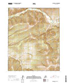
2017 Map of Livengood C-3 NE
USGS Topo · Published 2017About this map
The interior of the Yukon-Koyukuk region unfolds across this topographic study, defined by an intricate drainage system within the Livengood C-3 NE quadrangle. High ridges divide the headwaters of numerous streams, including the north-flowing Bear Cr and Grouse Cr. In the southern portion of the sheet, Paystreak Cr and Moose Cr navigate the valley floors, suggesting the gold-seeking history common to this part of Alaska where creek names often reflected the aspirations of early prospectors. The terrain is marked by sharp elevation changes between Wolf Cr and the heights of the surrounding divides. This 2017 data captures the uninhabited character of the landscape, providing a clear view of the natural watercourses like Flat Cr and Crater Cr before they join larger systems beyond the quadrangle boundaries.
Find a feature on this map
15 named features on this map. Tap any name to fly to it.
Don’t see what you’re looking for? This feature index may not catch every label — zoom into the map to look around manually.
Map Details
Editions of this 2017 Livengood C-3 NE Map
This is the sole edition of this map. No revisions or reprints were ever made.
Other maps of this area

1945 · Livengood
USGS Topo · 1:250,000

1951 · Livengood
USGS Topo · 1:250,000

1951 · Livengood D-3
USGS Topo · 1:63,360

1951 · Livengood C-2
USGS Topo · 1:63,360

1952 · Livengood D-2
USGS Topo · 1:63,360

1954 · Livengood C-2
USGS Topo · 1:63,360
1954 · Livengood D-2
USGS Topo · 1:63,360
1954 · Livengood C-3
USGS Topo · 1:63,360
1954 · Livengood D-3
USGS Topo · 1:63,360

1956 · Livengood
USGS Topo · 1:250,000