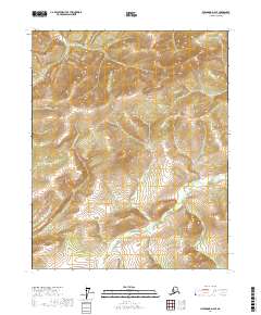
2017 Map of Livengood D-2 SE
USGS Topo · Published 2017About this map
Victoria Cr winds through the southern landscape of this Yukon-Koyukuk Census Area quadrangle, defining the drainage patterns of a largely undeveloped subarctic terrain. The interior Alaskan geography is characterized by several distinct watercourses, including Bear Cr and Grouse Cr, which originate in the higher elevations and flow toward the Victoria Creek basin. Surveyed in 2017, the map illustrates the precise township and range boundaries of t12n r1w and t11n r1e, which provide a formal grid over the varied topography. This document is particularly useful for understanding the natural hydrologic networks of the region, such as the northern reaches of Lost Cr, in an area devoid of modern road infrastructure or permanent settlements.
Find a feature on this map
8 named features on this map. Tap any name to fly to it.
Don’t see what you’re looking for? This feature index may not catch every label — zoom into the map to look around manually.
Map Details
Editions of this 2017 Livengood D-2 SE Map
This is the sole edition of this map. No revisions or reprints were ever made.
Other maps of this area

1945 · Livengood
USGS Topo · 1:250,000

1951 · Livengood
USGS Topo · 1:250,000

1951 · Livengood C-2
USGS Topo · 1:63,360

1951 · Livengood C-1
USGS Topo · 1:63,360

1952 · Livengood D-2
USGS Topo · 1:63,360

1952 · Livengood D-1
USGS Topo · 1:63,360

1954 · Livengood C-2
USGS Topo · 1:63,360

1954 · Livengood C-1
USGS Topo · 1:63,360
1954 · Livengood D-2
USGS Topo · 1:63,360
1954 · Livengood D-1
USGS Topo · 1:63,360