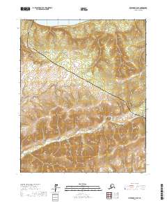
2017 Map of Livengood D-6 SE
USGS Topo · Published 2017About this map
The Yukon River flows along the northern edge of this interior landscape, marking a vital historical corridor through the Yukon-Koyukuk region. This 2017 study illustrates the intersection of modern industrial infrastructure with the remote Alaskan wilderness, most notably where the Alaska Pipeline traverses the terrain. This engineering feat, which snakes from the northwest down toward the southeast, parallels the rugged path of the Dalton Highway, the primary overland supply route for the North Slope oil fields. The topography is defined by significant elevation changes, with the northern lowlands near the river giving way to high ridges and drainage basins. Among these is Isom Cr, which carves through the southern portion of the quadrangle. For researchers, the map provides a clear record of how 21st-century utility corridors have been superimposed upon the natural hydrology and traditional transit paths of the northern interior.
Find a feature on this map
10 named features on this map. Tap any name to fly to it.
Don’t see what you’re looking for? This feature index may not catch every label — zoom into the map to look around manually.
Map Details
Editions of this 2017 Livengood D-6 SE Map
This is the sole edition of this map. No revisions or reprints were ever made.
Other maps of this area

1945 · Livengood
USGS Topo · 1:250,000

1951 · Livengood
USGS Topo · 1:250,000

1952 · Livengood C-5
USGS Topo · 1:63,360

1952 · Livengood D-5
USGS Topo · 1:63,360

1956 · Livengood C-6
USGS Topo · 1:63,360

1956 · Livengood D-6
USGS Topo · 1:63,360

1956 · Livengood
USGS Topo · 1:250,000

1964 · Livengood
USGS Topo · 1:250,000
2017 · Livengood C-5 NW
USGS Topo · 1:25,000
2017 · Livengood C-6 NE
USGS Topo · 1:25,000