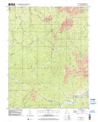
1996 Map of Lockwood
USGS Topo · Published 2002About this map
Lockwood and Lyonsville anchor the southern reaches of this Appalachian landscape, where the confluence of Otter Creek and Peters Creek defines the local geography. The area's mid-1990s industrial character is marked by numerous Strip Mine sites and extensive clusters of gas wells concentrated in the northern hills. Along the winding course of Twentymile Creek, small rural nodes like Fola persist alongside landmarks such as the Otter Creek Sch and the Lick Fork Freewill Ch. The terrain is characterized by a dense network of branches and forks, including Peachorchard Branch and Hardway Branch, which carve through the distinct civil districts of Henry, Grant, and Jefferson. This survey records the late 20th-century extraction economy, capturing the infrastructure of pipelines and resource pits that shaped the Nicholas and Clay county borderlands.
Find a feature on this map
55 named features on this map. Tap any name to fly to it.
Don’t see what you’re looking for? This feature index may not catch every label — zoom into the map to look around manually.
Map Details
Editions of this 1996 Lockwood Map
This is the sole edition of this map. No revisions or reprints were ever made.
Other maps of this area

1889 · Nicholas
USGS Topo · 1:125,000

1891 · Nicholas
USGS Topo · 1:125,000

1897 · Kanawha Falls
USGS Topo · 1:125,000

1900 · Kanawha Falls
USGS Topo · 1:125,000

1901 · Nicholas
USGS Topo · 1:125,000

1901 · Kanawha Falls
USGS Topo · 1:125,000

1908 · Clay
USGS Topo · 1:48,000

1908 · Fayetteville
USGS Topo · 1:48,000

1910 · Clay
USGS Topo · 1:62,500

1910 · Fayetteville
USGS Topo · 1:62,500