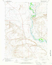
1963 Map of Lombard Buttes
USGS Topo · Published 1966About this map
The Emigrant Trail tracks through this arid landscape along the western bank of the Green River, marking a corridor of historical movement through Sweetwater County. This mid-century survey documents a topography defined by erosion and water management, where the Big Sandy River joins the larger Green River system. The presence of irrigation infrastructure like Hamp Ditch No 2 and a smaller Ditch near Telephone Island indicates the continued effort to reclaim the desert for agriculture and livestock. Settlement is sparse and focused on isolated outposts such as Dunkle Ranch and Johnson Ranch, while the namesake Lombard Buttes and Lombard Road dominate the western portion of the quadrangle. Geologists and local historians can trace the intersection of ancient travel routes with modern land use, from the meandering river islands like Freezeout Island to early energy exploration evidenced by a Drill Hole.
Find a feature on this map
18 named features on this map. Tap any name to fly to it.
Don’t see what you’re looking for? This feature index may not catch every label — zoom into the map to look around manually.
Map Details
Editions of this 1963 Lombard Buttes Map
2 editions found
Other maps of this area

1954 · Rock Springs
USGS Topo · 1:250,000

1958 · Rock Springs
USGS Topo · 1:250,000

1961 · Blue Point
USGS Topo · 1:24,000

1961 · Sevenmile Gulch
USGS Topo · 1:24,000

1961 · Stevens Flat
USGS Topo · 1:24,000

1962 · Rock Springs
USGS Topo · 1:250,000

1963 · Gasson Bridge
USGS Topo · 1:24,000

1963 · Big Island Bridge
USGS Topo · 1:24,000
1963 · Whiskey Buttes
USGS Topo · 1:24,000
1963 · Mc Cullen Bluff
USGS Topo · 1:24,000