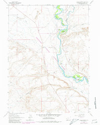
1963 Map of Lombard Buttes
USGS Topo · Published 1980About this map
Lombard Buttes and the high plains of Sweetwater County define this landscape during the mid-twentieth century, centered on the confluence where the Big Sandy River meets the Green River. This riverine corridor is protected within the Seedskadee National Wildlife Refuge, where the water supports narrow ribbons of green through the Little Colorado Desert. The presence of the historic Emigrant Trail cutting through the center of the sheet highlights the area's legacy as a vital thoroughfare for westward travelers. Small-scale irrigation and cattle ranching are evident through features like Hamp Ditch No 2, Otterson Ditch, and isolated outposts such as Dunkle Ranch and Johnson Ranch. The map also details river islands like Freezout Island and Telephone Island, showing the shifting channels of this critical Wyoming waterway before late-century developments changed the local hydrology.
Find a feature on this map
17 named features on this map. Tap any name to fly to it.
Don’t see what you’re looking for? This feature index may not catch every label — zoom into the map to look around manually.
Map Details
Editions of this 1963 Lombard Buttes Map
2 editions found
Other maps of this area

1954 · Rock Springs
USGS Topo · 1:250,000

1958 · Rock Springs
USGS Topo · 1:250,000

1961 · Blue Point
USGS Topo · 1:24,000

1961 · Sevenmile Gulch
USGS Topo · 1:24,000

1961 · Stevens Flat
USGS Topo · 1:24,000

1962 · Rock Springs
USGS Topo · 1:250,000

1963 · Gasson Bridge
USGS Topo · 1:24,000

1963 · Big Island Bridge
USGS Topo · 1:24,000
1963 · Whiskey Buttes
USGS Topo · 1:24,000
1963 · Mc Cullen Bluff
USGS Topo · 1:24,000