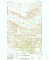
1958 Map of Lone Butte
USGS Topo · Published 1982About this map
The Little Missouri River meanders through this landscape, carving through the badlands of McKenzie County. This map documents a stretch of the Theodore Roosevelt National Memorial Park along its western edge, where the terrain rises toward high plateaus. The topography is dominated by distinct landforms like Lone Butte, Morman Butte, and Square Top, which served as critical navigation points for early ranchers and travelers in the Missouri River Basin. The presence of the Murray Ranch near the riverbank illustrates the historical reliance on these waterways for early agricultural development. This survey was conducted as part of the Department of the Interior program for the development of the Missouri River Basin, capturing the network of ephemeral drainages such as Spring Creek, Dry Creek, and Sand Creek that define the hydraulic character of the region.
Find a feature on this map
21 named features on this map. Tap any name to fly to it.
Don’t see what you’re looking for? This feature index may not catch every label — zoom into the map to look around manually.
Map Details
Editions of this 1958 Lone Butte Map
2 editions found
Other maps of this area

1953 · Watford City
USGS Topo · 1:250,000

1957 · Watford City
USGS Topo · 1:250,000

1958 · Long X Divide
USGS Topo · 1:24,000

1958 · Lone Butte SE
USGS Topo · 1:24,000

1958 · Lone Butte
USGS Topo · 1:24,000

1958 · Tepee Buttes
USGS Topo · 1:24,000

1959 · Lone Butte NW
USGS Topo · 1:24,000

1959 · Lone Butte NE
USGS Topo · 1:24,000

1967 · Watford City
USGS Topo · 1:250,000

1974 · Petes Creek
USGS Topo · 1:24,000