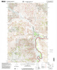
1997 Map of Lone Butte NE
USGS Topo · Published 2001About this map
The Little Missouri River carves a deep valley through this western North Dakota landscape, where the broken badlands of Bear Den meet the open expanse of the Little Missouri National Grassland. This 1997 revision of 1956 topography documents a ranching-driven geography, with isolated homesteads such as the M Johnson Ranch and K Hover Ranch positioned near vital water sources like Cherry Creek and Elhorn Creek. The map provides a clear look at the land survey system of the era, marked by the Twelfth Standard Parallel North and the boundary between McKenzie and Dunn Counties. Significant landmarks like Haystack Butte and Round Top Butte rise above the drainage networks of Rough Creek, while numerous Springs and a Flowing Well indicate the critical role of groundwater in this arid environment.
Find a feature on this map
20 named features on this map. Tap any name to fly to it.
Don’t see what you’re looking for? This feature index may not catch every label — zoom into the map to look around manually.
Map Details
Editions of this 1997 Lone Butte NE Map
This is the sole edition of this map. No revisions or reprints were ever made.
Other maps of this area

1953 · Watford City
USGS Topo · 1:250,000

1957 · Watford City
USGS Topo · 1:250,000

1958 · Lone Butte SE
USGS Topo · 1:24,000

1958 · Lone Butte
USGS Topo · 1:24,000

1958 · North Killdeer Mountain
USGS Topo · 1:24,000

1959 · Lone Butte NW
USGS Topo · 1:24,000

1959 · Croff
USGS Topo · 1:24,000

1959 · Lone Butte NE
USGS Topo · 1:24,000

1965 · Johnsons Corner
USGS Topo · 1:24,000

1967 · Watford City
USGS Topo · 1:250,000