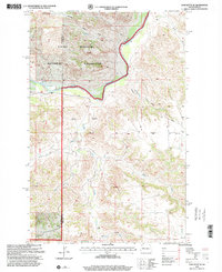
1997 Map of Lone Butte SE
USGS Topo · Published 2001About this map
The Little Missouri River carves a deep valley through this western North Dakota landscape, marking the northern reach of the Little Missouri National Grassland. The terrain is defined by the prominent Lone Butte and the industrial presence of the Lone Butte Oil Field, which spans across the central plains and coulees. This 1997 revision captures a complex network of drainage systems, including Crosby Creek and Cottonwood Creek, which feed into the river valley. The map documents the rural infrastructure of the late 20th century, notably the Quilliam Sch situated near the county boundary where Mc Kenzie and Dunn counties meet. This area reflects the dual nature of the Badlands, where protected federal grasslands and energy extraction activities coexist among the plateaus and gulches.
Find a feature on this map
13 named features on this map. Tap any name to fly to it.
Don’t see what you’re looking for? This feature index may not catch every label — zoom into the map to look around manually.
Map Details
Editions of this 1997 Lone Butte SE Map
This is the sole edition of this map. No revisions or reprints were ever made.
Other maps of this area

1953 · Watford City
USGS Topo · 1:250,000

1957 · Watford City
USGS Topo · 1:250,000

1958 · Lone Butte SE
USGS Topo · 1:24,000

1958 · Lone Butte
USGS Topo · 1:24,000

1958 · North Killdeer Mountain
USGS Topo · 1:24,000

1959 · Lone Butte NW
USGS Topo · 1:24,000

1959 · Croff
USGS Topo · 1:24,000

1959 · Lone Butte NE
USGS Topo · 1:24,000

1967 · Watford City
USGS Topo · 1:250,000

1974 · Killdeer
USGS Topo · 1:100,000