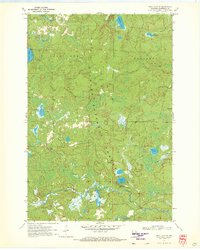
1970 Map of Long Lake SE
USGS Topo · Published 1972About this map
Nicolet National Forest dominates this northern Wisconsin landscape, where a dense network of glacial lakes and wetlands defines the geography. The map documents a primitive outdoor infrastructure during the early 1970s, highlighting the Morgan Lake Campground and the nearby Chapel of St Pius X. While the terrain remains largely undeveloped, the presence of a Railroad Grade and a Gravel Pit indicates the legacy of earlier industrial or extractive activities in the area. Waterways like the Popple River and Pine River cut through the forest, serving as the primary natural corridors. This survey provides a clear view of the lakeshore access points, including the Boat Ramp on Halsey Lake, reflecting the region's mid-century role as a remote recreation destination.
Find a feature on this map
25 named features on this map. Tap any name to fly to it.
Don’t see what you’re looking for? This feature index may not catch every label — zoom into the map to look around manually.
Map Details
Editions of this 1970 Long Lake SE Map
2 editions found
Other maps of this area

1939 · Goodman
USGS Topo · 1:48,000

1939 · Laona
USGS Topo · 1:48,000

1939 · Long Lake
USGS Topo · 1:48,000

1941 · Florence
USGS Topo · 1:48,000

1946 · Laona
USGS Topo · 1:48,000

1946 · Goodman
USGS Topo · 1:48,000

1947 · Naults
USGS Topo · 1:24,000

1948 · Long Lake
USGS Topo · 1:48,000

1954 · Iron Mountain
USGS Topo · 1:250,000

1959 · Iron Mountain
USGS Topo · 1:250,000