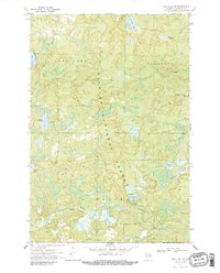
1970 Map of Long Lake SE
USGS Topo · Published 1987About this map
The Nicolet National Forest encompasses this section of Northern Wisconsin, dominated by a dense network of waterways and timberland in Florence County. The landscape is defined by the eastward flow of the Pine River in the north and the Popple River in the south, connected by numerous named tributaries including Riley Creek and Hendricks Creek. Evidence of earlier industrial activity remains visible in the Old Railroad Grade that cuts through the western terrain, while more modern recreational development is noted at the Morgan Lake Campground and its nearby Picnic Area. Local landmarks such as the Chapel of St Pius X and several glacial water bodies like Halsey Lake and Lake Seventeen provide key reference points for those studying the mid-century development of this forested region.
Find a feature on this map
25 named features on this map. Tap any name to fly to it.
Don’t see what you’re looking for? This feature index may not catch every label — zoom into the map to look around manually.
Map Details
Editions of this 1970 Long Lake SE Map
2 editions found
Other maps of this area

1939 · Goodman
USGS Topo · 1:48,000

1939 · Laona
USGS Topo · 1:48,000

1939 · Long Lake
USGS Topo · 1:48,000

1941 · Florence
USGS Topo · 1:48,000

1946 · Laona
USGS Topo · 1:48,000

1946 · Goodman
USGS Topo · 1:48,000

1947 · Naults
USGS Topo · 1:24,000

1948 · Long Lake
USGS Topo · 1:48,000

1954 · Iron Mountain
USGS Topo · 1:250,000

1959 · Iron Mountain
USGS Topo · 1:250,000