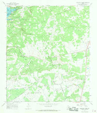
1967 Map of Longhorn Cavern
USGS Topo · Published 1969About this map
Longhorn Cavern State Park and Inks Lake State Park anchor this Central Texas landscape during the late 1960s, documenting a region defined by its cavernous geology and the controlled waters of the Colorado River. The topography is dominated by the massive formation of Backbone Ridge and the broad Backbone Valley, which channel numerous tributaries such as Honey Creek and Peters Creek toward the reservoir.
Find a feature on this map
32 named features on this map. Tap any name to fly to it.
Don’t see what you’re looking for? This feature index may not catch every label — zoom into the map to look around manually.
Map Details
Editions of this 1967 Longhorn Cavern Map
3 editions found
Other maps of this area

1887 · Burnet
USGS Topo · 1:125,000

1893 · Burnet
USGS Topo · 1:125,000

1903 · Burnet
USGS Topo · 1:125,000

1909 · Burnet
USGS Topo · 1:125,000

1925 · Burnet 3-b
USGS Topo · 1:48,000
1925 · Burnet 2-c
USGS Topo · 1:48,000

1925 · Burnet 3-d
USGS Topo · 1:48,000

1929 · Marble Falls
USGS Topo · 1:62,500

1931 · Marble Falls
USGS Topo · 1:48,000

1932 · Tow
USGS Topo · 1:62,500