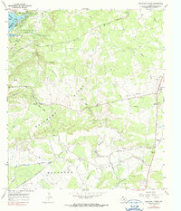
1967 Map of Longhorn Cavern
USGS Topo · Published 1990About this map
Longhorn Cavern State Park dominates the rugged central topography of this Burnet County landscape, where the subterranean features of the Longhorn Cavern Entrance meet the elevated relief of Backbone Ridge. To the northwest, the impounded waters of Inks Lake on the Colorado River contrast with the agricultural and industrial activity found in Backbone Valley. The survey records a mid-century infrastructure of extraction and transport, notably the numerous Gravel Pits and a Quarry situated along the Southern Pacific railroad line. Small community clusters such as Fairland, Sudduth, and Hylton are mapped alongside local landmarks like Tobey Cem and a remote Landing Strip, providing a clear view of rural Texas Hill Country life and industry before major modern developments changed the character of these smaller settlements.
Find a feature on this map
37 named features on this map. Tap any name to fly to it.
Don’t see what you’re looking for? This feature index may not catch every label — zoom into the map to look around manually.
Map Details
Editions of this 1967 Longhorn Cavern Map
3 editions found
Other maps of this area

1887 · Burnet
USGS Topo · 1:125,000

1893 · Burnet
USGS Topo · 1:125,000

1903 · Burnet
USGS Topo · 1:125,000

1909 · Burnet
USGS Topo · 1:125,000

1925 · Burnet 3-b
USGS Topo · 1:48,000
1925 · Burnet 2-c
USGS Topo · 1:48,000

1925 · Burnet 3-d
USGS Topo · 1:48,000

1929 · Marble Falls
USGS Topo · 1:62,500

1931 · Marble Falls
USGS Topo · 1:48,000

1932 · Tow
USGS Topo · 1:62,500