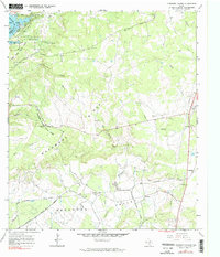
1967 Map of Longhorn Cavern
USGS Topo · Published 1990About this map
Longhorn Cavern State Park and the rugged topography of Backbone Ridge dominate this Texas Hill Country landscape during the late 1960s. The survey captures the subterranean significance of the area, specifically identifying the Longhorn Cavern Entrance amidst a terrain of limestone and springs. To the northwest, the Colorado River feeds into Inks Lake, where Inks Lake State Park establishes a recreational footprint alongside the rising elevation of the ridge.
Find a feature on this map
34 named features on this map. Tap any name to fly to it.
Don’t see what you’re looking for? This feature index may not catch every label — zoom into the map to look around manually.
Map Details
Editions of this 1967 Longhorn Cavern Map
3 editions found
Other maps of this area

1887 · Burnet
USGS Topo · 1:125,000

1893 · Burnet
USGS Topo · 1:125,000

1903 · Burnet
USGS Topo · 1:125,000

1909 · Burnet
USGS Topo · 1:125,000

1925 · Burnet 3-b
USGS Topo · 1:48,000
1925 · Burnet 2-c
USGS Topo · 1:48,000

1925 · Burnet 3-d
USGS Topo · 1:48,000

1929 · Marble Falls
USGS Topo · 1:62,500

1931 · Marble Falls
USGS Topo · 1:48,000

1932 · Tow
USGS Topo · 1:62,500